
About GMRT
The Global Multi-Resolution Topography (GMRT) Synthesis is one of the world's leading open-access seafloor mapping resources, providing scientists, government agencies, educators, industry, and the public with access to the highest-resolution bathymetric data available. By transforming decades of multibeam sonar surveys into a seamless global map, GMRT helps advance ocean exploration, natural hazard assessment, marine resource management, scientific discovery, and national ocean mapping priorities. GMRT ensures that publicly collected bathymetric data remain accessible and usable. Open access accelerates scientific discovery, supports innovation, reduces duplication of effort, and expands opportunities for education and workforce development.
Why Ocean Mapping Matters
- Exploration — More than 70% of Earth's surface lies beneath the ocean, yet much of the seafloor remains unmapped.
- Scientific Discovery — Seafloor maps reveal underwater volcanoes, canyons, fault systems, habitats, and previously unknown geological features.
- Natural Hazards — Bathymetry is essential for tsunami modeling, earthquake studies, and coastal resilience planning.
- National Security — Accurate seafloor maps support navigation, submarine cable planning, maritime awareness, and strategic operations.
- Economic Growth — Ocean mapping supports fisheries, offshore energy, shipping, and the blue economy.
Supporting Ocean Mapping Priorities
GMRT supports national and international efforts to improve knowledge of the seafloor, including priorities identified through the National Strategy for Ocean Mapping, Exploring, and Characterizing the U.S. Exclusive Economic Zone (NOMEC) and global initiatives such as Seabed 2030. By making high-quality bathymetric data openly accessible, GMRT helps transform individual surveys into a lasting openly available data resource.
Technical Overview
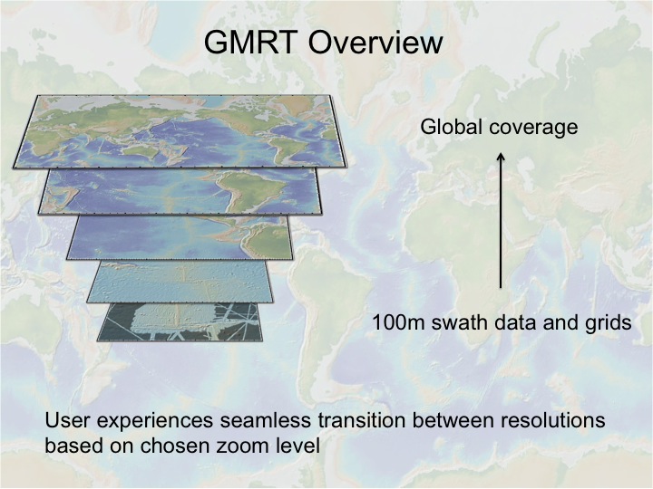
The Global Multi-Resolution Topography (GMRT) Synthesis is a multi-resolution Digital Elevation Model (DEM) maintained in three projections and supported by a scalable global architecture that enables access to the DEM as grids, images, points, and profiles. A mask layer for each projection highlights where high-resolution data contribute to the compilation.
Most of GMRT’s curatorial effort is focused on cleaning and processing ship-based multibeam sonar data acquired by the U.S. Academic Research Fleet (ARF) so they can be gridded at full spatial resolution (typically ~100 m in the deep sea). These activities also support U.S. priorities for seafloor exploration and characterization by improving the discoverability, accessibility, and usability of bathymetric data for research, operational planning, hazard assessment, and ocean management. Curated multibeam data are blended and merged with other elevation sources to create a global multi-resolution DEM, and GMRT services are optimized to deliver the best available resolution for each user’s area of interest.
Multibeam bathymetry is unique among marine geophysical data types in its broad relevance across scientific disciplines and non-academic applications. It provides foundational characterization of the physical environment and serves as a primary base map for multidisciplinary research and decision support. While specialized expertise and software are typically required to access, quality control, and process multibeam files into high-quality bathymetric maps, the GMRT Synthesis provides free, open access to bathymetric imagery and gridded bathymetry for both specialist and non-specialist users. Details on the tiling approach and procedures used to generate and serve the GMRT Synthesis are provided in Ryan et al., 2009.
Source Data & Resolution
GMRT brings together multiple elevation sources that are managed as four discrete source types, each updated on a different schedule.
- Ship-based multibeam swath bathymetry data (120-m resolution) from research expeditions are assessed, cleaned, processed and curated by the GMRT Team and are updated with each GMRT release. The current version (GMRT v4.5.0) was released in June 2026 and includes swath data from 1,644 surveys covering 44,896,399 square kilometers or 12.41% of the global ocean.
- Gridded seafloor depth data sets that have been contributed by the international science community and are updated with each release. The grids capture a wide range of resolutions.
- Portions of the US at 10-m resolution from the USGS National Elevation Dataset (NED)
- Global data (30-m resolution) from the joint NASA-Japanese Advanced Spaceborne Thermal Emission and Reflection Radiometer (ASTER) global DEM
- Gridded seafloor depth data (15 arc-second resolution) from the General Bathymetric Chart of the Oceans (GEBCO 2026)
- Gridded seafloor depth data (2-km resolution) from the International Bathymetric Chart of the Arctic Ocean (IBCAO) version 2.23
- Gridded seafloor depth data and ice surface data (500-m resolution) from the International Bathymetric Chart of the Southern Ocean (IBCSO)
GMRT Multibeam Bathymetry Synthesis
Contributed Grids
Terrestrial elevation data
International data compilation base maps assembled by the GEBCO community
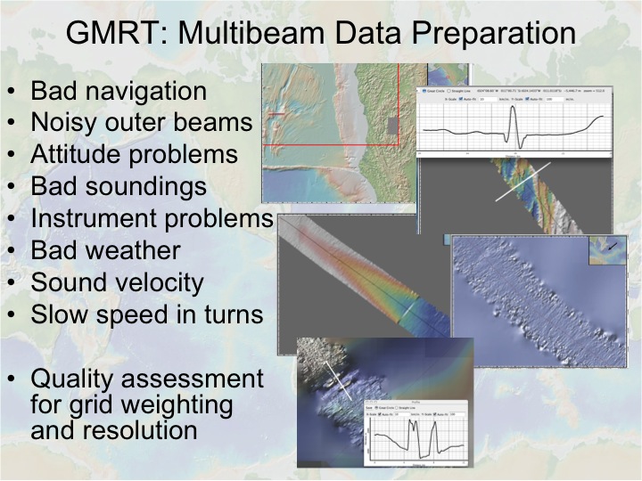
MB Swath Data Preparation
Where do the source data come from?
Raw sonar data are only the starting point. The GMRT team reviews, cleans, standardizes, and integrates data from multiple sources to create a trusted, interoperable resource that can be used by scientists, educators, government agencies, and decision-makers worldwide.
We make use of multibeam data that are in the public domain at the NOAA National Centers for Environmental Information (NCEI). Our efforts are focused primarily on the US Academic Research Fleet, but we also evaluate and include data that are in the public domain from non-US sources. Our cruise-level metadata now includes information about the organization that processed the data, so the efforts of community members can be acknowledged and recognized. In addition to the data that have been included in GMRT, several multibeam surveys have been reviewed and not included - typically because they do not provide new coverage, and sometimes because of significant issues with data quality. Additional processed and/or gridded data are also contributed directly by scientists for inclusion in GMRT. Please contact us if you would like to contribute data.
How are data prioritized for inclusion in GMRT?
We prioritize data for inclusion in the GMRT synthesis based on several criteria including: (1) extent of coverage and/or survey area, (2) the needs of NSF-funded research initiatives (e.g. GeoPRISMS), and (3) quality of sonar system. Having worked through much of the available archive of legacy data, our primary focus is now on data from recent research expeditions. Please contact us to request that we prioritize data from a particular cruise or area.
How may users request that new data is added to GMRT?
Please contact us if you would like to contribute data to GMRT or request that publicly available data be added to the compilation.
How are swath data processed?
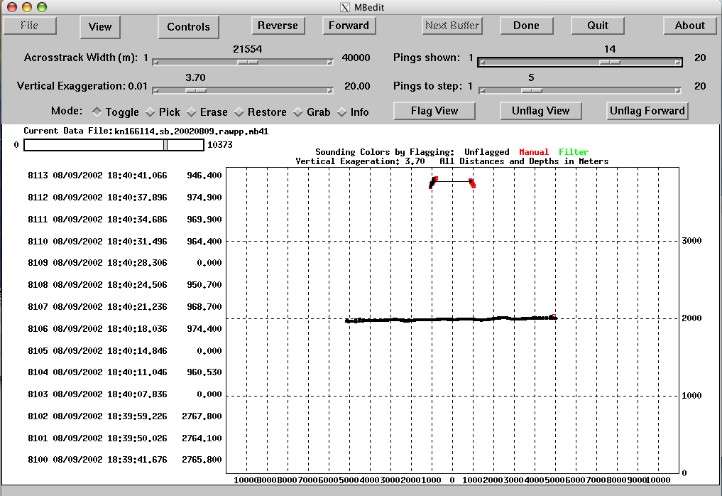
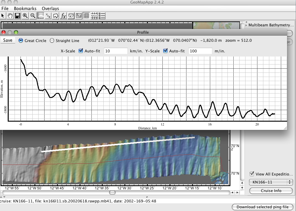
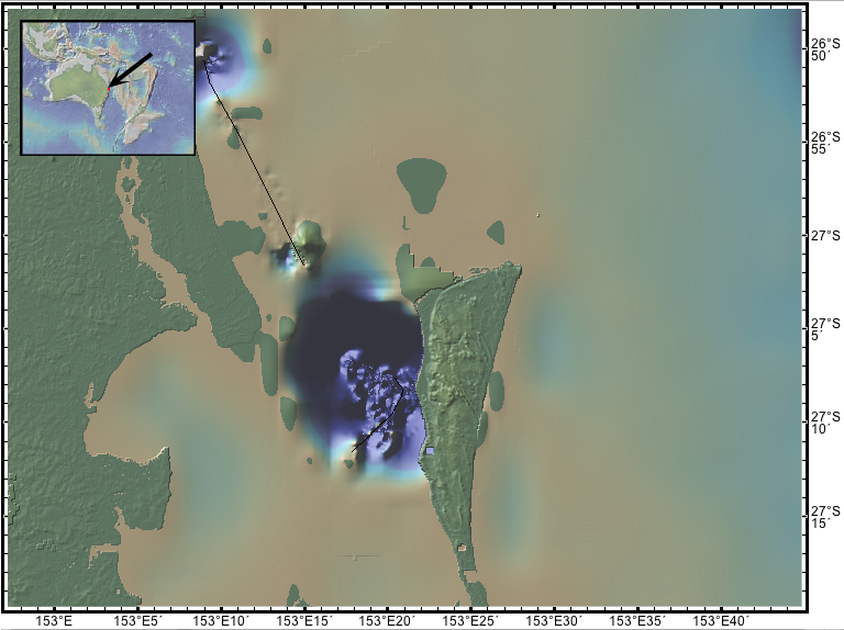
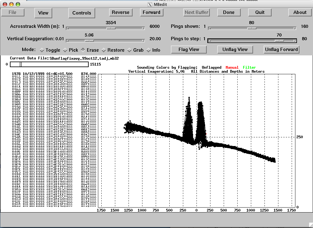
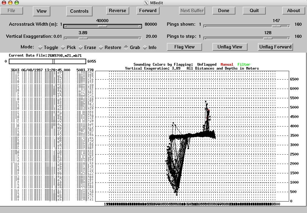
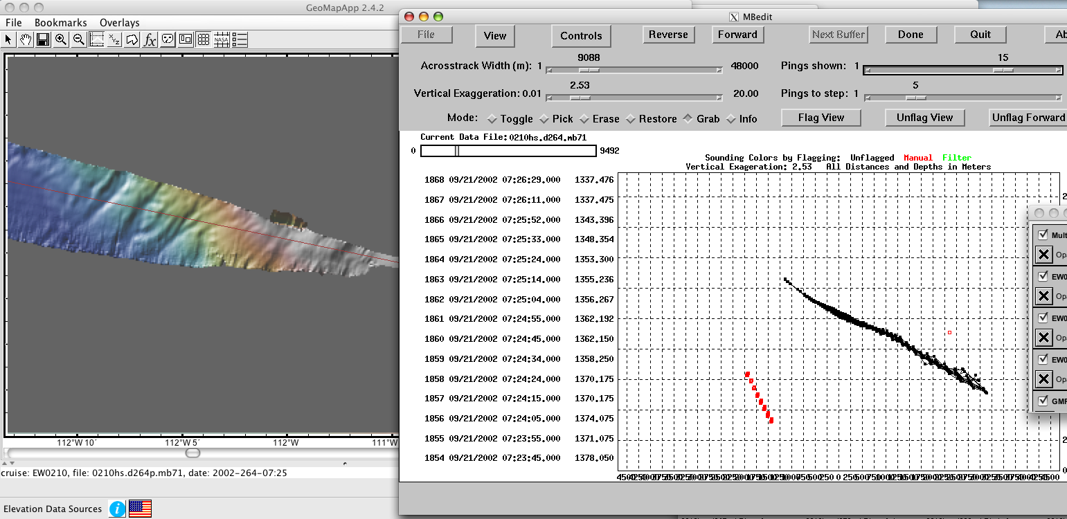
We use a combination of software developed in-house along with open-source software to process swath data for GMRT. MB-System provides the backbone of the code that we use for our data cleaning and processing. If only raw multibeam sonar ping files are available for a particular cruise, the files are first run through a series of filters to elimate the biggest outliers, and then are used to generate a development set of 120-m resolution tiled images and grids using GMRT-Tiler. These tiled images and grids are reviewed and quantitatively interrogated using GeoMapApp. This allows our team to assess data coverage and data quality, and to identify data problems that can be addressed using multibeam processing tools and techniques available through MB-System.
Multibeam swath data are typically processed to 120-m horizontal resolution. While our overall goal is to include only high-quality data, we sometimes include lower quality data in areas where data coverage is sparse (e.g. Southern Ocean). The data are reviewed, edited as necessary and re-gridded iteratively until the quality is suitable for inclusion in the GMRT tile set. During this process, we also determine the maximum data resolution for the cruise - the data are gridded at 100m (default), 50m, or 25m resolution depending on sonar system capabilities, data quality, and survey area. The chosen resolution is applied to the entire cruise and is therefore limited by maximum water depth. During QA/QC, a quality value ranging from 1-10 with 10 representing the highest data quality, is assigned to the cruise. This value is applied as a weighting factor to the data and affects the degree of blending that happens when the data are merged with the existing GMRT compilation.
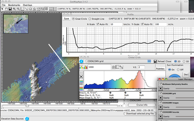
Image Gallery of Common Problems Addressed During Multibeam Data Preparation:
Crowd-sourcing Data Curation
We have made our gridding and tiling tools available so partner organizations and individuals may participate in the QA/QC of multibeam data in order to accelerate the pace of data integration. The tools and instructions are available here.
Can the processing be automated?
Unfortunately, no. The successful processing and cleaning of sonar data collected at a variety of geologic settings throughout the global ocean requires human intervention. While some automatic filtering techniques may be used for subsets of data, the generation of a consistent, high-quality GMRT data product necessitates manual review and decision-making.
Accessing GMRT Grids & Images
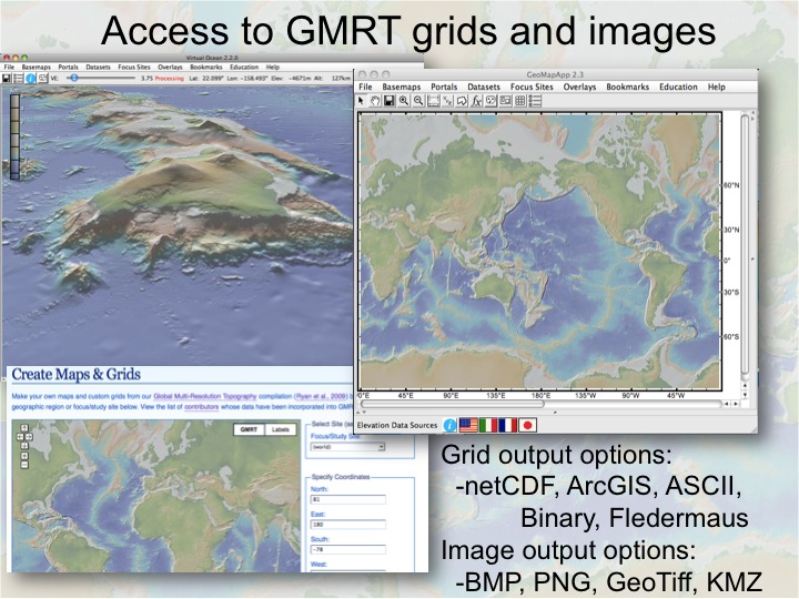
- GMRT MapTool is an online tool that allows users to generate custom maps and grids directly from the GMRT compilation.
- GMRT is the default base map in our visualization and analysis tool GeoMapApp, which can be used to create custom maps and grids, and to import and analyze other data sets within the context of GMRT.
- GMRT images may be accessed as a Web Map Service (WMS).
- The 120-m resolution swath layer of GMRT is integrated as part of the default ocean layer in Google Earth and Google Maps.
GMRT History & Evolution
- 1992 - Bathymetry synthesis began as the Ridge Multibeam Synthesis Project (RMBS) - a compilation of gridded data products from global MORs.
- 2003 - Bathymetry compilation was expanded to include the Southern Ocean with the initiation of GMRT to provide global access to multi-resolutional bathymetry data.
- 2004 - GeoMapApp version 1.1 provides access to the GMRT compilation
- 2005 - The scope of GMRT was expanded to include data from throughout global oceans beyond MORs and the Southern Ocean.
- 2005 - GMRT Web Services established to broaden access to GMRT.
- 2008 - Virtual Ocean (3D Virtual Globe) released.
- 2009 - GMRT Synthesis Paper published in G-cubed (Ryan et al., 2009)
- 2010 - GMRT version 2.0 – revised tiling scheme, new data prep tools, improved quality, improved land resolution, extended swath coverage
- 2010 - Earth Observer released for iPhone and iPad
- 2011 - GMRT 120-m swath bathymetry content added Google Earth & Google Maps
- 2009 - GMRT version 1.0 released in September with processed swath data from 364 additional surveys, representing 1,367,332 new trackline miles of data. This brings the total area covered by our curated swath bathymetry to 12,307,275 square km (3.40% of the global ocean). The SRTM ocean base map was used in this version.
- 2011 - GMRT version 2.0 released in January with processed swath data from 129 additional surveys, representing 390,035 new trackline miles of data. This brings the total area covered by our curated swath bathymetry to 17,165,415 square km (4.74% of the global ocean). The SRTM ocean base map was used in this version.
- 2011 - GMRT version 2.1 released in September with processed swath data from 77 additional surveys, representing 206,317 new trackline miles of data. This brings the total area covered by our curated swath bathymetry to 18,410,254 square km (5.09% of the global ocean). The SRTM ocean base map was used in this version.
- 2012 - GMRT version 2.2 released in April with processed swath data from 41 additional surveys, representing 125,992 new trackline miles of data. This brings the total area covered by our curated swath bathymetry to 19,747,632 square km (5.46% of the global ocean). The SRTM ocean base map was used in this version.
- 2012 - GMRT version 2.3 released in October with processed swath data from 37 additional surveys, representing 81,505 new trackline miles of data. This brings the total area covered by our curated swath bathymetry to 20,607,140 square km (5.69% of the global ocean). The SRTM ocean base map was used in this version.
- 2013 - GMRT version 2.4 released in April with processed swath data from 40 additional surveys, representing 67,441 new trackline miles of data. This brings the total area covered by our curated swath bathymetry to 21,426,216 square km (5.92% of the global ocean). The SRTM ocean base map was used in this version.
- 2013 - GMRT version 2.5 released in October with processed swath data from 42 additional surveys, representing 132,221 new trackline miles of data. This brings the total area covered by our curated swath bathymetry to 22,934,999 square km (6.34% of the global ocean). The SRTM ocean base map was used in this version.
- 2014 - GMRT version 2.6 released in May with processed swath data from 48 additional surveys, representing 148,590 new trackline miles of data. This brings the total area covered by our curated swath bathymetry to 24,714,312 square km (6.83% of the global ocean). The SRTM ocean base map was used in this version.
- 2014 - GMRT version 2.7 released in November with processed swath data from 29 additional surveys, representing 105,828 new trackline miles of data. This brings the total area covered by our curated swath bathymetry to 25,649,288 square km (7.09% of the global ocean). The SRTM ocean base map was used in this version.
- 2015 - GMRT version 3.0 released in June with processed swath data from 38 additional surveys, representing 97,998 new trackline miles of data. This brings the total area covered by our curated swath bathymetry to 26,569,856 square km (7.34% of the global ocean). The GEBCO 2014 ocean base map was used in this version.
- 2015 - GMRT version 3.1 released in November with processed swath data from 31 additional surveys, representing 67,300 new trackline miles of data. This brings the total area covered by our curated swath bathymetry to 27,074,228 square km (7.48% of the global ocean). The GEBCO 2014 ocean base map was used in this version.
- 2016 - GMRT version 3.2 released in June with processed swath data from 28 additional surveys, representing 97,709 new trackline miles of data. This brings the total area covered by our curated swath bathymetry to 27,921,901 square km (7.72% of the global ocean). The GEBCO 2014 ocean base map was used in this version.
- 2017 - GMRT version 3.3 released in January with processed swath data from 28 additional surveys, representing 90,133 new trackline miles of data. This brings the total area covered by our curated swath bathymetry to 28,819,725 square km (7.96% of the global ocean). The GEBCO 2014 ocean base map was used in this version.
- 2017 - GMRT version 3.4 released in July with processed swath data from 43 additional surveys, representing 33,317 new trackline miles of data. This brings the total area covered by our curated swath bathymetry to 29,241,643 square km (8.08% of the global ocean). The GEBCO 2014 ocean base map was used in this version.
- 2018 - GMRT version 3.5 released in February with processed swath data from 33 additional surveys, representing 90,088 new trackline miles of data. This brings the total area covered by our curated swath bathymetry to 30,130,308 square km (8.33% of the global ocean). The GEBCO 2014 ocean base map was used in this version.
- 2018 - GMRT version 3.6 released in December with processed swath data from 38 additional surveys, representing 102,301 new trackline miles of data. This brings the total area covered by our curated swath bathymetry to 31,278,025 square km (8.64% of the global ocean). The GEBCO 2014 ocean base map was used in this version.
- 2019 - GMRT version 3.7 released in October with processed swath data from 62 additional surveys, representing 155,766 new trackline miles of data. This brings the total area covered by our curated swath bathymetry to 32,790,531 square km (9.06% of the global ocean). The GEBCO 2014 ocean base map was used in this version.
- 2020 - GMRT version 3.8 released in October with processed swath data from 84 additional surveys, representing 171,537 new trackline miles of data. This brings the total area covered by our curated swath bathymetry to 34,764,597 square km (9.61% of the global ocean). The GEBCO 2014 ocean base map was used in this version.
- 2021 - GMRT version 3.9 released in March with processed swath data from 47 additional surveys, representing 82,175 new trackline miles of data. This brings the total area covered by our curated swath bathymetry to 35,696,795 square km (9.86% of the global ocean). The GEBCO 2014 ocean base map was used in this version.
- 2022 - GMRT version 4.0 released in January with processed swath data from 87 additional surveys, representing 170,430 new trackline miles of data. This brings the total area covered by our curated swath bathymetry to 37,245,848 square km (10.29% of the global ocean). The GEBCO 2021 ocean base map was used in this version.
- 2022 - GMRT version 4.1 released in October with processed swath data from 61 additional surveys, representing 82,131 new trackline miles of data. This brings the total area covered by our curated swath bathymetry to 38,133,571 square km (10.54% of the global ocean). The GEBCO 2022 ocean base map was used in this version.
- 2023 - GMRT version 4.1.1 released in March with processed swath data from 39 additional surveys, representing 105,812 new trackline miles of data. This brings the total area covered by our curated swath bathymetry to 38,992,688 square km (10.77% of the global ocean). The GEBCO 2022 ocean base map was used in this version.
- 2023 - GMRT version 4.2 released in November with processed swath data from 30 additional surveys, representing 74,666 new trackline miles of data. This brings the total area covered by our curated swath bathymetry to 39,737,223 square km (10.98% of the global ocean). The GEBCO 2023 ocean base map was used in this version.
- 2024 - GMRT version 4.2.1 released in May with processed swath data from 34 additional surveys, representing 87,483 new trackline miles of data. This brings the total area covered by our curated swath bathymetry to 40,838,234 square km (11.28% of the global ocean). The GEBCO 2023 ocean base map was used in this version.
- 2024 - GMRT version 4.3.0 released in October with processed swath data from 30 additional surveys, representing 87,330 new trackline miles of data. This brings the total area covered by our curated swath bathymetry to 41,511,053 square km (11.47% of the global ocean). The GEBCO 2024 ocean base map was used in this version.
- 2025 - GMRT version 4.3.1 released in April with processed swath data from 34 additional surveys, representing 70,114 new trackline miles of data. This brings the total area covered by our curated swath bathymetry to 42,253,845 square km (11.68% of the global ocean). The GEBCO 2024 ocean base map was used in this version.
- 2025 - GMRT version 4.4.0 released in August with processed swath data from 24 additional surveys, representing 72,382 new trackline miles of data. This brings the total area covered by our curated swath bathymetry to 43,048,817 square km (11.90% of the global ocean). The GEBCO 2025 ocean base map was used in this version.
- 2026 - GMRT version 4.4.1 released in January with processed swath data from 43 additional surveys, representing 102,303 new trackline miles of data. This brings the total area covered by our curated swath bathymetry to 44,116,654 square km (12.19% of the global ocean). The GEBCO 2025 ocean base map was used in this version.
- 2026 - GMRT version 4.5.0 released in June with processed swath data from 23 additional surveys, representing 65,202 new trackline miles of data. This brings the total area covered by our curated swath bathymetry to 44,896,399 square km (12.41% of the global ocean). The GEBCO 2026 ocean base map was used in this version.
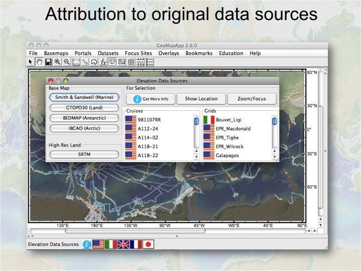
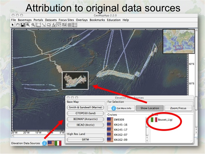
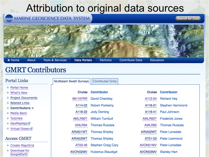
Attribution to Original Data Sources
Attribution to data providers has always been a priority with the GMRT synthesis, and is accomplished in several ways through different applications and user interfaces. Visit our Contributors for a full list of current data sources.
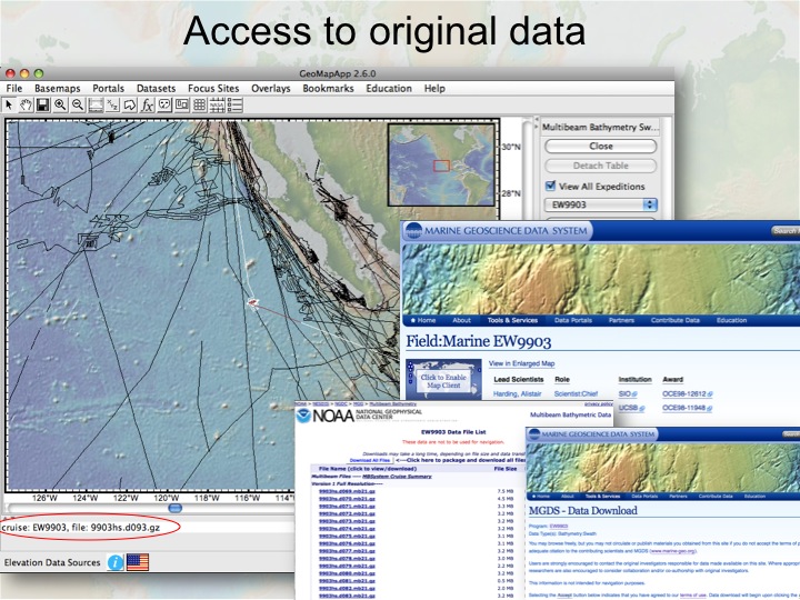
Access to Source Data
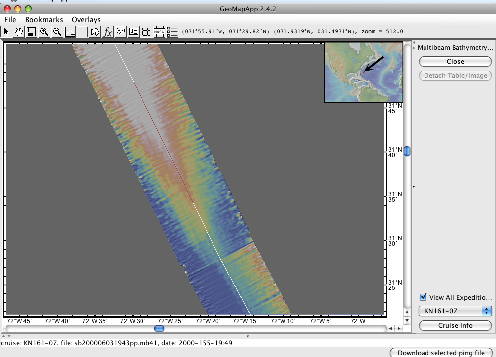
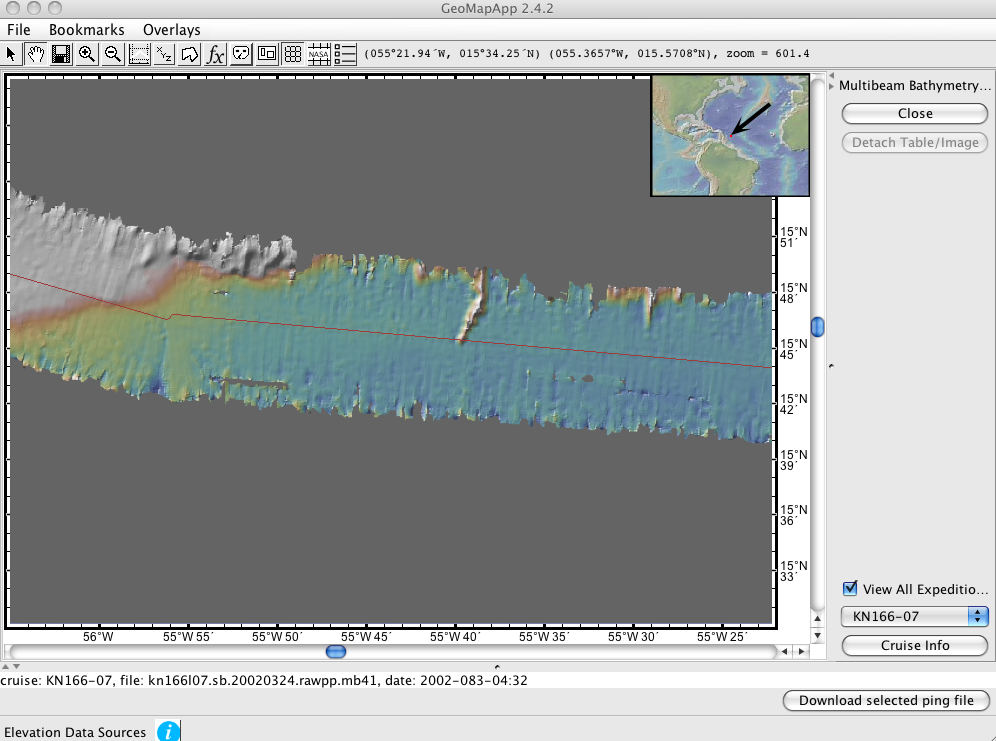
As one of the few global bathymetric compilations to provide direct access to both gridded products and original multibeam files—with full provenance and attribution—GMRT is a model for open science, transparency, and maximizing return on public investment. Advanced users who seek access to processed multibeam sonar files used in the GMRT compilation may identify and download processed multibeam files using the Multibeam Swath Bathymetry Data Portal in GeoMapApp, as follows: open the Multibeam Swath Bathymetry Portal and click on a trackline of interest - the entire trackline for that cruise will be illuminated, with the individual swath file shown in red. The name of the chosen swath file is displayed in the bottom left of the GeoMapApp interface. Click the Download File button to save the file locally.
How to contribute to GMRT
You may send gridded data products and/or raw or processed swath files to us for potential inclusion in the GMRT compilation here. We will use our data evaluation tools and processes to review the data to ensure that it meets GMRT quality standards prior to integration. If you work with swath data, we invite you to explore the use of our GMRT-Tiler tools which are available through GitHub.
How to cite GMRT
Ryan, W.B.F., S.M. Carbotte, J.O. Coplan, S. O'Hara, A. Melkonian, R. Arko, R.A. Weissel, V. Ferrini, A. Goodwillie, F. Nitsche, J. Bonczkowski, and R. Zemsky (2009), Global Multi-Resolution Topography synthesis, Geochem. Geophys. Geosyst., 10, Q03014, doi: 10.1029/2008GC002332
